Themovision Tomography
TVT Unique Features & Advantages
- Wide area coverage and Deep Penetration
- Ability to aerially scan 500km2 per satellite swoop.
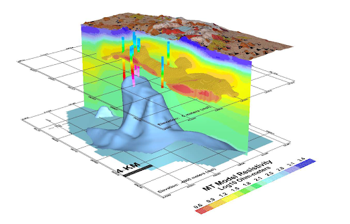
- Produces layers of image slices on maps down to 100km depth
- High Accuracy
- No false call since inception more than 15 years ago in more than 41 projects in over 21 countries
- Short execution period
- <1,000sq.km: 3-6 months; >5,000sq.km: >7 months
- High Speed Delivery of Results
- More cost-effective vs. traditional methods
- Accurate delineation of geological structures
- Requires no physical presence and deployment of bulky equipment
- Elimination of community mediation challenges, thus saving time, cost & efforts
- No inaccessible areas (Terrain independent), No weather barriers
- Zero HSE Risk, 100% human safety
- No Unproductive and Dry wells
- Can detect reasons for low production
- Prevent drilling of dry wells
- Not affected by Gas Clouds
- Hydrocarbon Identification and quantitative estimates of geological reserves
- Can differentiate Oil vs Gas accumulation in reservoirs
Wide range of applications together with obvious advantage trio “fast-cheap-effective” makes Thermovision Tomography (TVT) the future of geological and geophysical studies.
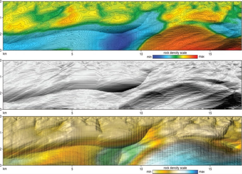
The geophysical technology of Thermovision Tomography (TVT) was developed in the early 2000. This is an innovative technology that greatly facilitates the search for various minerals (hydrocarbons, solid minerals, underground water deposits, etc.), faster, cheaper and more accurate. The technology is based on the study of the thermal properties of rocks and uses satellite images in the far infrared wavelength range as a source material. it does not require any bulky equipment, no need to carry out on-ground works on license blocks, and work begins immediately after obtaining the coordinates of the corner points of the site
Our Key Services include Exploration of

Solid Minerals
We offer effective and accurate services of Thermovision capable to accomplish exploration of large areas within short period of time to map mineral wealth of your nation.
- Maps with locations of favourable signs of specific ores
- Geothermal sections & map of blocks
- Identification of detectable ores of metallic minerals:
Ferrous (Iron, Chromium, Manganese, titanium)
– Non Ferrous(Copper, Lead, Zinc, Nickel)
– Rare & Precious metals (Gold, tin, tungsten, molybdenum, platinum, niobium, tantalum)
– Radioactive metals (Uranium)
– Industrial raw materials (Diamonds, limestone, bitumen, barite, etc.)
– 3D model of mineral deposits
- Recommendations for conducting deep litho-geochemical surveys in the search for ore bodies with
exact GPS positions for drilling. - Quantification of the different solid mineral reserve after geochemistry analysis

Oil & Gas
Exploration of a territory of several thousand square kilometers can actually take only half a year. Even middle-size private companies can afford it and save years of research and millions of dollars.
- 3D model of oil and gas deposits and other minerals
- Comprehensive hydrocarbon migration pattern / report
- Approximate estimated reserves of the block
- Exact GPS coordinates for recommended drilling point
- Vertical and horizontal profiles (sections) of geological environment at a given depth
- Maps of spectral indicators of environmental landscape systems.

Underground Water Sources
The thermovision tomography allows
- Check of underground water traps quality.
- detection of ruptures via monitoring of discharge spot of deep waters, and its effect on the integrity of a deposit.
- detection of fluid accumulation areas and areas with increased permeable based on developed geothermal criteria.

Geothermal heat sources
TVT Benefits to Clients

- Possibility of effective planning of exploration works.
- Obtaining the licenses and concentrate all the efforts only on the most promising areas
- Significant minimization of cost-intensive ground based work

- Prospectively assessment of licensed block
- Rapid evaluation of risks of investment into solid mineral mines
- Most important tool to avoid opportunistic fraud by obtaining correct geographical data

- Quick and complete information about the mineral potential of the country / region.
- Great tool for government agencies before offering licenses to mining companies
- Very effective method for evaluation of expenses made by using traditional technologies
TVT Geography of our projects

Existing since 1985, OilDynamix Limited is an international company providing quality services in the Oil and Gas Sector.
Contact Us
Uk Office – 86 Gordon Place, Bridge of Don, Aberdeen AB32 8RB, UK
Nigeria Office – F2H Bourdillon Court, Chevron Drive, Lekki, Lagos, Nigeria
Phone – +234 8169189004,
+45 7852455036
Email – info@oildynamix.com